[vc_row type=”full_width_background” full_screen_row_position=”middle” column_margin=”none” equal_height=”yes” content_placement=”middle” column_direction=”default” column_direction_tablet=”default” column_direction_phone=”default” bg_image=”51766″ bg_position=”right bottom” background_image_loading=”skip-lazy-load” bg_repeat=”no-repeat” full_height=”yes” scene_position=”center” bottom_padding=”0″ top_padding_tablet=”100″ top_padding_phone=”0″ text_color=”dark” text_align=”left” row_border_radius=”none” row_border_radius_applies=”bg” class=”homepage1 tablet-align-center bg-black main_section white” overlay_strength=”0.3″ gradient_direction=”left_to_right” shape_divider_position=”bottom” bg_image_animation=”none” shape_type=””][vc_column column_padding=”no-extra-padding” column_padding_tablet=”inherit” column_padding_phone=”inherit” column_padding_position=”all” constrain_group_2=”yes” column_element_spacing=”default” background_color_opacity=”1″ background_hover_color_opacity=”1″ column_shadow=”none” column_border_radius=”none” column_link_target=”_self” max_width_desktop=”100%” gradient_direction=”left_to_right” overlay_strength=”0.3″ width=”1/3″ tablet_width_inherit=”default” tablet_text_alignment=”default” phone_text_alignment=”default” bg_image_animation=”none” border_type=”simple” column_border_width=”none” column_border_style=”solid”][vc_column_text css=”.vc_custom_1639565451955{margin-right: 0px !important;margin-left: 0px !important;border-right-width: 0px !important;border-left-width: 0px !important;padding-right: 0px !important;padding-left: 0px !important;}” el_class=”disp-abso mobil-hide”]
The water management platform that brings teams together
[/vc_column_text][vc_column_text css=”.vc_custom_1639565457786{margin-right: 0px !important;margin-left: 0px !important;border-right-width: 0px !important;border-left-width: 0px !important;padding-right: 0px !important;padding-left: 0px !important;}” el_class=”disp-abso desktop-hide”]
The water management platform that brings teams together
[/vc_column_text][vc_column_text el_class=”padding-top-130 tablet-align-center hide-movil”]Give your planning and operations teams a clear and actionable view of their water network.[/vc_column_text][nectar_btn size=”medium” button_style=”see-through” button_color_2=”Extra-Color-3″ color_override=”#ffffff” icon_family=”default_arrow” el_class=”button-violet button-violet-hover-3 hide-movil product-popup” text=”Product tour” margin_top=”30″ url=”#”][/vc_column][vc_column column_padding=”no-extra-padding” column_padding_tablet=”inherit” column_padding_phone=”inherit” column_padding_position=”all” bottom_margin=”0″ column_element_spacing=”0px” background_color_opacity=”1″ background_hover_color_opacity=”1″ column_shadow=”none” column_border_radius=”none” column_link_target=”_self” gradient_direction=”left_to_right” overlay_strength=”0.3″ width=”2/3″ tablet_width_inherit=”default” tablet_text_alignment=”default” phone_text_alignment=”default” bg_image_animation=”none” border_type=”simple” column_border_width=”none” column_border_style=”solid”][vc_column_text el_class=”hide-desk-tablet hero-subtitle”]Give your planning and operations teams a clear and actionable view of their network.[/vc_column_text][nectar_btn size=”medium” open_new_tab=”true” button_style=”see-through” button_color_2=”Extra-Color-3″ color_override=”#ffffff” icon_family=”default_arrow” el_class=”button-violet button-violet-hover-3 hide-desk-tablet product-popup” text=”Product tour” url=”#”][vc_column_text]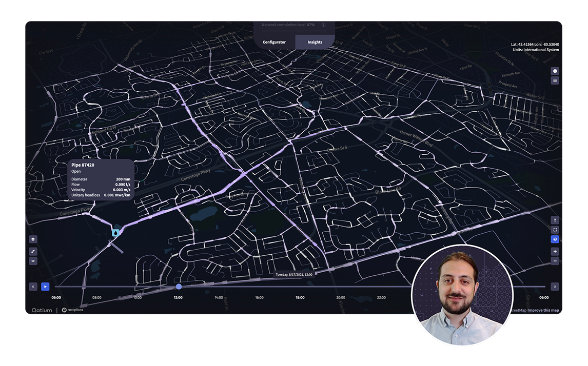
 [/vc_column_text][/vc_column][vc_column column_padding=”no-extra-padding” column_padding_tablet=”inherit” column_padding_phone=”inherit” column_padding_position=”all” column_element_spacing=”default” background_color_opacity=”1″ background_hover_color_opacity=”1″ column_shadow=”none” column_border_radius=”none” column_link_target=”_self” el_class=”txt-center” gradient_direction=”left_to_right” overlay_strength=”0.3″ width=”1/1″ tablet_width_inherit=”default” tablet_text_alignment=”default” phone_text_alignment=”default” bg_image_animation=”none” border_type=”simple” column_border_width=”none” column_border_style=”solid”][image_with_animation image_url=”47700″ animation=”None” hover_animation=”none” alignment=”center” border_radius=”none” box_shadow=”none” image_loading=”default” max_width=”custom” img_link=”#rtoc-1″ max_width_custom=”50″][/vc_column][/vc_row][vc_row type=”in_container” full_screen_row_position=”middle” column_margin=”none” column_direction=”default” column_direction_tablet=”default” column_direction_phone=”default” scene_position=”center” top_padding=”140″ top_padding_phone=”140″ text_color=”dark” text_align=”left” row_border_radius=”none” row_border_radius_applies=”bg” class=”homepage1 bg-white main_section black” id=”move-the-industry” overlay_strength=”0.3″ gradient_direction=”left_to_right” shape_divider_position=”bottom” bg_image_animation=”none” shape_type=””][vc_column column_padding=”no-extra-padding” column_padding_tablet=”inherit” column_padding_phone=”inherit” column_padding_position=”all” top_margin_phone=”0″ column_element_spacing=”default” background_color_opacity=”1″ background_hover_color_opacity=”1″ column_shadow=”none” column_border_radius=”none” column_link_target=”_self” el_class=”tablet-align-center” gradient_direction=”left_to_right” overlay_strength=”0.3″ width=”1/1″ tablet_width_inherit=”default” tablet_text_alignment=”default” phone_text_alignment=”default” bg_image_animation=”none” border_type=”simple” column_border_width=”none” column_border_style=”solid”][vc_column_text el_id=”move”]
Show the way forward
[/vc_column_text][vc_column_text css_animation=”fadeInUp” el_class=”mobile-hide” css=”.vc_custom_1638931063164{padding-top: 30px !important;}”]
Orchestrate your GIS data sets, hydraulic models and real-time sensors like never before.[/vc_column_text][vc_column_text css_animation=”fadeInUp” css=”.vc_custom_1639491430483{padding-top: 10px !important;}” el_class=”only-mobile”]
Orchestrate your GIS data sets, hydraulic models and real-time sensors like never before.[/vc_column_text][vc_row_inner equal_height=”yes” content_placement=”middle” column_margin=”default” column_direction=”default” column_direction_tablet=”default” column_direction_phone=”default” top_padding=”70″ bottom_padding=”0″ top_padding_phone=”30″ text_align=”left”][vc_column_inner column_padding=”no-extra-padding” column_padding_tablet=”inherit” column_padding_phone=”inherit” column_padding_position=”all” bottom_margin_tablet=”0″ column_element_spacing=”default” background_color_opacity=”1″ background_hover_color_opacity=”1″ column_shadow=”none” column_border_radius=”none” column_link_target=”_self” gradient_direction=”left_to_right” overlay_strength=”0.3″ width=”1/2″ tablet_width_inherit=”default” bg_image_animation=”none” border_type=”simple” column_border_width=”none” column_border_style=”solid”][vc_column_text css=”.vc_custom_1639334530599{margin-bottom: 20px !important;border-bottom-width: 0px !important;}” el_class=”hide-desk-tablet”]
AI-AssistedData Management
[/vc_column_text][image_with_animation image_url=”117346″ animation=”Fade In From Bottom” hover_animation=”none” alignment=”” border_radius=”none” box_shadow=”none” image_loading=”default” max_width=”100%” max_width_mobile=”default” margin_bottom_tablet=”0″ margin_bottom_phone=”20″ el_class=”trans12″][/vc_column_inner][vc_column_inner column_padding=”padding-7-percent” column_padding_tablet=”no-extra-padding” column_padding_phone=”no-extra-padding” column_padding_position=”left” column_element_spacing=”default” background_color_opacity=”1″ background_hover_color_opacity=”1″ column_shadow=”none” column_border_radius=”none” column_link_target=”_self” gradient_direction=”left_to_right” overlay_strength=”0.3″ width=”1/2″ tablet_width_inherit=”default” bg_image_animation=”none” border_type=”simple” column_border_width=”none” column_border_style=”solid”][vc_column_text css=”.vc_custom_1635376828075{margin-bottom: 20px !important;border-bottom-width: 0px !important;}” el_class=”hide-movil”]
AI-Assisted Data Management
[/vc_column_text][vc_column_text max_width=”400px”]Enrich GIS data and validate hydraulic models. Visualize and share your network in 3D.[/vc_column_text][nectar_btn size=”medium” button_style=”see-through” button_color_2=”Extra-Color-3″ color_override=”#252224″ icon_family=”default_arrow” el_class=”button-orange2 button-animation-hover-1″ text=”Take a closer look” margin_bottom=”0″ margin_top=”30″ url=”https://qatium.com/product/”][/vc_column_inner][/vc_row_inner][vc_row_inner equal_height=”yes” content_placement=”middle” column_margin=”default” column_direction=”default” column_direction_tablet=”default” column_direction_phone=”default” text_align=”left”][vc_column_inner column_padding=”no-extra-padding” column_padding_tablet=”inherit” column_padding_phone=”inherit” column_padding_position=”all” top_margin_phone=”50″ column_element_spacing=”default” background_color_opacity=”1″ background_hover_color_opacity=”1″ column_shadow=”none” column_border_radius=”none” column_link_target=”_self” gradient_direction=”left_to_right” overlay_strength=”0.3″ width=”1/2″ tablet_width_inherit=”default” bg_image_animation=”none” border_type=”simple” column_border_width=”none” column_border_style=”solid”][vc_column_text css=”.vc_custom_1639170621193{margin-bottom: 0px !important;border-bottom-width: 0px !important;}” el_class=”hide-desk-tablet”]
Real-TimeSimulations
[/vc_column_text][image_with_animation image_url=”117370″ animation=”Fade In From Bottom” hover_animation=”none” alignment=”” border_radius=”none” box_shadow=”none” image_loading=”default” max_width=”100%” max_width_mobile=”default” el_class=”hide-desk trans12″ margin_top_phone=”20″ margin_bottom_phone=”20″][vc_column_text el_class=”hide-desk”]
Run real-time operational scenarios and assess network resilience.
[/vc_column_text][vc_column_text css=”.vc_custom_1639170606558{margin-bottom: 20px !important;border-bottom-width: 0px !important;padding-left: 30px !important;}” el_class=”hide-movil”]
Real-Time Simulations
[/vc_column_text][vc_column_text css=”.vc_custom_1675955173571{margin-left: 30px !important;}” el_class=”hide-movil”]
Run real-time operational scenarios and assess
network resilience.
[/vc_column_text][nectar_btn size=”medium” button_style=”see-through” button_color_2=”Extra-Color-3″ color_override=”#252224″ icon_family=”default_arrow” el_class=”button-violet button-violet-hover-3 real-sim-button” text=”See use cases” url=”https://qatium.com/use-cases/”][/vc_column_inner][vc_column_inner column_padding=”no-extra-padding” column_padding_tablet=”inherit” column_padding_phone=”inherit” column_padding_position=”all” column_element_spacing=”default” background_color_opacity=”1″ background_hover_color_opacity=”1″ column_shadow=”none” column_border_radius=”none” column_link_target=”_self” el_class=”hide-tablet” gradient_direction=”left_to_right” overlay_strength=”0.3″ width=”1/2″ tablet_width_inherit=”default” bg_image_animation=”none” border_type=”simple” column_border_width=”none” column_border_style=”solid”][image_with_animation image_url=”117370″ animation=”Fade In From Bottom” hover_animation=”none” alignment=”” border_radius=”none” box_shadow=”none” image_loading=”default” max_width=”100%” max_width_mobile=”default” el_class=”hide-tablet trans12″][/vc_column_inner][/vc_row_inner][vc_row_inner equal_height=”yes” content_placement=”middle” column_margin=”default” column_direction=”default” column_direction_tablet=”default” column_direction_phone=”default” bottom_padding=”140″ bottom_padding_phone=”50″ text_align=”left”][vc_column_inner column_padding=”no-extra-padding” column_padding_tablet=”inherit” column_padding_phone=”inherit” column_padding_position=”all” top_margin_phone=”50″ column_element_spacing=”default” background_color_opacity=”1″ background_hover_color_opacity=”1″ column_shadow=”none” column_border_radius=”none” column_link_target=”_self” gradient_direction=”left_to_right” overlay_strength=”0.3″ width=”1/2″ tablet_width_inherit=”default” bg_image_animation=”none” border_type=”simple” column_border_width=”none” column_border_style=”solid”][vc_column_text css=”.vc_custom_1639010165003{margin-bottom: 0px !important;border-bottom-width: 0px !important;}” el_class=”hide-desk-tablet”]
Open Roadmap and APIs
[/vc_column_text][image_with_animation image_url=”117394″ animation=”Fade In From Bottom” hover_animation=”none” alignment=”” border_radius=”none” box_shadow=”none” image_loading=”default” max_width=”100%” max_width_mobile=”default” margin_top_phone=”30″ margin_bottom_phone=”20″ el_class=”trans12″][/vc_column_inner][vc_column_inner column_padding=”padding-7-percent” column_padding_tablet=”no-extra-padding” column_padding_phone=”no-extra-padding” column_padding_position=”left” column_element_spacing=”default” background_color_opacity=”1″ background_hover_color_opacity=”1″ column_shadow=”none” column_border_radius=”none” column_link_target=”_self” gradient_direction=”left_to_right” overlay_strength=”0.3″ width=”1/2″ tablet_width_inherit=”default” bg_image_animation=”none” border_type=”simple” column_border_width=”none” column_border_style=”solid”][vc_column_text css=”.vc_custom_1634865225368{margin-bottom: 20px !important;border-bottom-width: 0px !important;}” el_class=”hide-movil”]
Open Roadmap and APIs
[/vc_column_text][vc_column_text max_width=”400″]Build or extend your apps with Qatium’s APIs. Upvote features and get them on the roadmap. [/vc_column_text][nectar_btn size=”medium” button_style=”see-through” button_color_2=”Extra-Color-3″ color_override=”#252224″ icon_family=”default_arrow” el_class=”button-gold button-violet-hover-3″ text=”View roadmap” margin_top=”30″ url=”https://qatium.com/roadmap/”][/vc_column_inner][/vc_row_inner][/vc_column][/vc_row][vc_row type=”full_width_background” full_screen_row_position=”middle” column_margin=”default” column_direction=”default” column_direction_tablet=”default” column_direction_phone=”default” bg_color=”#191923″ bg_image=”47892″ bg_position=”left top” background_image_loading=”default” bg_repeat=”no-repeat” scene_position=”center” top_padding=”140px” bottom_padding=”70px” top_padding_tablet=”65px” bottom_padding_tablet=”65px” top_padding_phone=”70px” constrain_group_5=”yes” bottom_padding_phone=”70px” text_color=”dark” text_align=”left” row_border_radius=”none” row_border_radius_applies=”bg” class=”homepage1-testimonial bg-black main_section white” overlay_strength=”0.3″ gradient_direction=”left_to_right” shape_divider_position=”bottom” bg_image_animation=”none” shape_type=””][vc_column column_padding=”no-extra-padding” column_padding_tablet=”inherit” column_padding_phone=”inherit” column_padding_position=”all” column_element_spacing=”default” centered_text=”true” background_color_opacity=”1″ background_hover_color_opacity=”1″ column_shadow=”none” column_border_radius=”none” column_link_target=”_self” gradient_direction=”left_to_right” overlay_strength=”0.3″ width=”1/1″ tablet_width_inherit=”default” tablet_text_alignment=”default” phone_text_alignment=”default” bg_image_animation=”none” border_type=”simple” column_border_width=”none” column_border_style=”solid”][vc_column_text css_animation=”fadeInUp” css=”.vc_custom_1639171245925{margin-bottom: 50px !important;}” el_class=”hide-movil”]
The water management platform your team will love
[/vc_column_text][vc_column_text css_animation=”fadeInUp” css=”.vc_custom_1634865349886{margin-bottom: 50px !important;}” el_class=”hide-desk-tablet”]
A range of experts we co-create with
[/vc_column_text][testimonial_slider style=”multiple_visible” color=”extra-color-2-light” autorotate=”8000″][testimonial image=”8152″ star_rating=”none” title=”Testimonial” id=”1675959467217-0″ name=”William Sarni” subtitle=”Founder and CEO at Water Foundry” quote=”Qatium has the ambition and opportunity to democratize water intelligence. And they have what it takes to make it happen.” tab_id=”1675959467217-10″][testimonial image=”8154″ star_rating=”none” title=”Testimonial” id=”1675959467228-9″ name=”Dragan Savic” subtitle=”CEO at KWR Water Research Institute. Professor of Hydroinformatics at the University of Exeter” quote=”With Qatium, operators can better understand network behavior, optimize system performance, and ensure continuity and resilience by proactively protecting assets and communities.” tab_id=”1675959467228-6″][testimonial image=”44971″ star_rating=”none” title=”Testimonial” id=”1675959467236-7″ name=”Newsha Ajami” subtitle=”Director of Urban Water Policy at Stanford University” quote=”The water sector is going through a paradigm shift and digitalization is at the center of that. Qatium enables this transformation while introducing transparency and promoting equitable access.” tab_id=”1675959467236-5″][testimonial image=”8144″ star_rating=”none” title=”Testimonial” id=”1675959467244-3″ name=”Enrique Cabrera” subtitle=”Vice President at International Water Association” quote=”Qatium offers a free, fully comprehensive, digital platform for water and wastewater; I’m confident it will revolutionize the way services are managed around the world.” tab_id=”1675959467244-4″][testimonial image=”8142″ star_rating=”none” title=”Testimonial” id=”1675959467250-4″ name=”Hassan Aboelnga” subtitle=”Vice Chair of the Middle East Water Forum and Researcher” quote=”Qatium can change the way water is managed today and achieve water security for everyone.” tab_id=”1675959467251-9″][testimonial image=”8148″ star_rating=”none” title=”Testimonial” id=”1675959467256-1″ name=”Tom Freyberg” subtitle=”Founder and Director of Atlantean Media” quote=”Actionable data is fundamental for smarter, sustainable and resilient water systems. This is exactly what Qatium is about.” tab_id=”1675959467257-6″][/testimonial_slider][nectar_btn size=”medium” button_style=”see-through” button_color_2=”Extra-Color-3″ color_override=”#ffffff” icon_family=”default_arrow” el_class=”button-violet button-violet-hover-3 real-sim-button” text=”See our experts” url=”/experts/”][/vc_column][/vc_row][vc_row type=”in_container” full_screen_row_position=”middle” column_margin=”none” equal_height=”yes” column_direction=”default” column_direction_tablet=”default” column_direction_phone=”default” scene_position=”center” top_padding=”140″ constrain_group_1=”yes” bottom_padding=”140″ top_padding_phone=”50″ bottom_padding_phone=”50″ left_padding_phone=”0″ right_padding_phone=”0″ text_color=”dark” text_align=”left” row_border_radius=”none” row_border_radius_applies=”bg” class=”bg-white main_section black” overlay_strength=”0.3″ gradient_direction=”left_to_right” shape_divider_position=”bottom” bg_image_animation=”none” shape_type=””][vc_column column_padding=”no-extra-padding” column_padding_tablet=”inherit” column_padding_phone=”inherit” column_padding_position=”all” column_element_spacing=”default” background_color_opacity=”1″ background_hover_color_opacity=”1″ column_shadow=”none” column_border_radius=”none” column_link_target=”_self” el_class=”tablet-align-center” gradient_direction=”left_to_right” overlay_strength=”0.3″ width=”1/1″ tablet_width_inherit=”default” tablet_text_alignment=”default” phone_text_alignment=”default” bg_image_animation=”none” border_type=”simple” column_border_width=”none” column_border_style=”solid”][vc_column_text el_class=”flow-title”]
Go with the flow
[/vc_column_text][vc_row_inner equal_height=”yes” column_margin=”100px” column_direction=”default” column_direction_tablet=”default” column_direction_phone=”default” text_align=”left”][vc_column_inner column_padding=”no-extra-padding” column_padding_tablet=”padding-5-percent” column_padding_phone=”no-extra-padding” column_padding_position=”all” constrain_group_6=”yes” column_element_spacing=”default” background_color_opacity=”1″ background_hover_color_opacity=”1″ column_shadow=”none” column_border_radius=”none” column_link_target=”_self” gradient_direction=”left_to_right” overlay_strength=”0.3″ width=”1/3″ tablet_width_inherit=”default” bg_image_animation=”none” border_type=”simple” column_border_width=”none” column_border_style=”solid”][image_with_animation image_url=”48092″ animation=”Fade In From Bottom” hover_animation=”none” alignment=”” border_radius=”none” box_shadow=”none” image_loading=”default” max_width=”100%” max_width_mobile=”default” delay=”200″ margin_top_phone=”50″ margin_bottom=”50″ margin_bottom_phone=”0″][vc_column_text css=”.vc_custom_1635382290699{margin-top: 0px !important;padding-bottom: 20px !important;}”]
A Simple Interface
[/vc_column_text][vc_column_text]The most user-friendly software in the water industry. No IT expertise required.[/vc_column_text][/vc_column_inner][vc_column_inner column_padding=”no-extra-padding” column_padding_tablet=”padding-5-percent” column_padding_phone=”no-extra-padding” column_padding_position=”all” column_element_spacing=”default” background_color_opacity=”1″ background_hover_color_opacity=”1″ column_shadow=”none” column_border_radius=”none” column_link_target=”_self” gradient_direction=”left_to_right” overlay_strength=”0.3″ width=”1/3″ tablet_width_inherit=”default” bg_image_animation=”none” border_type=”simple” column_border_width=”none” column_border_style=”solid”][image_with_animation image_url=”56009″ animation=”Fade In From Bottom” hover_animation=”none” alignment=”” border_radius=”none” box_shadow=”none” image_loading=”default” max_width=”100%” max_width_mobile=”default” margin_bottom_phone=”0″ margin_bottom=”50″ margin_top_phone=”50″][vc_column_text css=”.vc_custom_1635629095052{padding-bottom: 20px !important;}”]
Free and Accessible
[/vc_column_text][vc_column_text]Say goodbye to software headaches and hello to continuous updates.[/vc_column_text][/vc_column_inner][vc_column_inner column_padding=”no-extra-padding” column_padding_tablet=”padding-5-percent” column_padding_phone=”no-extra-padding” column_padding_position=”all” column_element_spacing=”default” background_color_opacity=”1″ background_hover_color_opacity=”1″ column_shadow=”none” column_border_radius=”none” column_link_target=”_self” gradient_direction=”left_to_right” overlay_strength=”0.3″ width=”1/3″ tablet_width_inherit=”default” bg_image_animation=”none” border_type=”simple” column_border_width=”none” column_border_style=”solid”][image_with_animation image_url=”56034″ animation=”Fade In From Bottom” hover_animation=”none” alignment=”” border_radius=”none” box_shadow=”none” image_loading=”default” max_width=”100%” max_width_mobile=”default” delay=”100″ margin_top_phone=”50″ margin_bottom=”50″ margin_bottom_phone=”0″][vc_column_text css=”.vc_custom_1635629082792{padding-bottom: 20px !important;}”]
An Open Community
[/vc_column_text][vc_column_text]Join a group of hydraulic modeling, GIS and IoT experts from around the world. [/vc_column_text][/vc_column_inner][/vc_row_inner][/vc_column][/vc_row][vc_row type=”full_width_background” full_screen_row_position=”middle” column_margin=”none” equal_height=”yes” content_placement=”middle” column_direction=”default” column_direction_tablet=”default” column_direction_phone=”default” bg_image=”48147″ bg_position=”left top” background_image_loading=”default” bg_repeat=”no-repeat” scene_position=”center” top_padding=”140″ constrain_group_1=”yes” bottom_padding=”140″ top_padding_phone=”50″ bottom_padding_phone=”50″ text_color=”dark” text_align=”left” row_border_radius=”none” row_border_radius_applies=”bg” class=”bg-black main_section white” overlay_strength=”0.3″ gradient_direction=”left_to_right” shape_divider_position=”bottom” bg_image_animation=”none” shape_type=””][vc_column column_padding=”padding-5-percent” column_padding_tablet=”inherit” column_padding_phone=”inherit” column_padding_position=”right” column_element_spacing=”default” background_color_opacity=”1″ background_hover_color_opacity=”1″ column_shadow=”none” column_border_radius=”none” column_link_target=”_self” el_class=”tablet-align-center secure-by” gradient_direction=”left_to_right” overlay_strength=”0.3″ width=”1/3″ tablet_width_inherit=”default” tablet_text_alignment=”default” phone_text_alignment=”default” bg_image_animation=”none” border_type=”simple” column_border_width=”none” column_border_style=”solid”][vc_column_text el_class=”secure-by” css=”.vc_custom_1634865534589{margin-bottom: 20px !important;}”]
Secure by design
[/vc_column_text][vc_column_text]Robust systems, processes and procedures to keep your data secure and private at all times. [/vc_column_text][nectar_btn size=”medium” button_style=”see-through” button_color_2=”Accent-Color” color_override=”#ffffff” icon_family=”default_arrow” el_class=”button-orange button-violet-hover-3 hide-movil” text=”Discover more” url=”https://qatium.com/security/”][/vc_column][vc_column column_padding=”no-extra-padding” column_padding_tablet=”inherit” column_padding_phone=”inherit” column_padding_position=”all” column_element_spacing=”default” centered_text=”true” background_color_opacity=”1″ background_hover_color_opacity=”1″ column_shadow=”none” column_border_radius=”none” column_link_target=”_self” gradient_direction=”left_to_right” overlay_strength=”0.3″ width=”2/3″ tablet_width_inherit=”default” tablet_text_alignment=”default” phone_text_alignment=”default” bg_image_animation=”none” border_type=”simple” column_border_width=”none” column_border_style=”solid”][image_with_animation image_url=”59835″ animation=”Fade In From Bottom” hover_animation=”none” alignment=”” border_radius=”none” box_shadow=”none” image_loading=”default” max_width=”100%” max_width_mobile=”default” el_class=”hide-movil”][image_with_animation image_url=”59860″ animation=”Fade In From Bottom” hover_animation=”none” alignment=”” border_radius=”none” box_shadow=”none” image_loading=”default” max_width=”100%” max_width_mobile=”default” el_class=”hide-desk-tablet mobile-sec-image”][nectar_btn size=”medium” button_style=”see-through” button_color_2=”Accent-Color” color_override=”#ffffff” icon_family=”default_arrow” el_class=”button-orange button-violet-hover-3 hide-desk-tablet” text=”Discover more” margin_top=”50″ url=”https://qatium.com/security?”][/vc_column][/vc_row][vc_row type=”in_container” full_screen_row_position=”middle” column_margin=”none” column_direction=”default” column_direction_tablet=”default” column_direction_phone=”default” scene_position=”center” top_padding=”140″ constrain_group_1=”yes” bottom_padding=”140″ top_padding_phone=”50″ bottom_padding_phone=”50″ text_color=”dark” text_align=”left” row_border_radius=”none” row_border_radius_applies=”bg” class=”bg-white main_section black” overlay_strength=”0.3″ gradient_direction=”left_to_right” shape_divider_position=”bottom” bg_image_animation=”none” shape_type=””][vc_column column_padding=”no-extra-padding” column_padding_tablet=”inherit” column_padding_phone=”inherit” column_padding_position=”all” column_element_spacing=”default” centered_text=”true” background_color_opacity=”1″ background_hover_color_opacity=”1″ column_shadow=”none” column_border_radius=”none” column_link_target=”_self” gradient_direction=”left_to_right” overlay_strength=”0.3″ width=”1/1″ tablet_width_inherit=”default” tablet_text_alignment=”default” phone_text_alignment=”default” bg_image_animation=”none” border_type=”simple” column_border_width=”none” column_border_style=”solid”][vc_column_text css=”.vc_custom_1643652365393{margin-bottom: 0px !important;border-bottom-width: 0px !important;}”]
An open roadmap
[/vc_column_text][image_with_animation image_url=”60821″ animation=”Fade In” hover_animation=”none” alignment=”center” border_radius=”none” box_shadow=”none” image_loading=”default” max_width=”custom” el_class=”hide-movil” margin_top=”100″ margin_top_phone=”0″ max_width_custom=”70%”][image_with_animation image_url=”60846″ animation=”Fade In” hover_animation=”none” alignment=”center” border_radius=”none” box_shadow=”none” image_loading=”default” max_width=”100%” max_width_mobile=”default” el_class=”hide-desk-tablet” margin_top=”0″ margin_top_phone=”50″][nectar_btn size=”medium” button_style=”see-through” button_color_2=”Extra-Color-3″ color_override=”#252224″ icon_family=”default_arrow” el_class=”button-violet button-violet-hover-3″ text=”See full roadmap” margin_top=”50″ url=”https://www.qatium.com/roadmap/”][/vc_column][/vc_row][vc_row type=”full_width_background” full_screen_row_position=”middle” column_margin=”default” column_direction=”default” column_direction_tablet=”default” column_direction_phone=”default” bg_image=”48233″ bg_position=”center center” background_image_loading=”default” bg_repeat=”no-repeat” scene_position=”center” top_padding=”200″ bottom_padding=”300″ bottom_padding_tablet=”300″ top_padding_phone=”50″ bottom_padding_phone=”400″ left_padding_phone=”0″ right_padding_phone=”0″ text_color=”dark” text_align=”center” row_border_radius=”none” row_border_radius_applies=”bg” class=”no-future-row bg-black main_section white” overlay_strength=”0.3″ gradient_direction=”left_to_right” shape_divider_position=”bottom” bg_image_animation=”none” shape_type=””][vc_column column_padding=”no-extra-padding” column_padding_tablet=”inherit” column_padding_phone=”inherit” column_padding_position=”all” left_margin_phone=”0″ right_margin_phone=”0″ column_element_spacing=”default” background_color_opacity=”1″ background_hover_color_opacity=”1″ column_shadow=”none” column_border_radius=”none” column_link_target=”_self” gradient_direction=”left_to_right” overlay_strength=”0.3″ width=”1/1″ tablet_width_inherit=”default” tablet_text_alignment=”default” phone_text_alignment=”default” bg_image_animation=”none” border_type=”simple” column_border_width=”none” column_border_style=”solid”][vc_column_text el_class=”nofuture-h2 hide-movil” css=”.vc_custom_1639991828557{margin-bottom: 5px !important;}”]
#NoFutureWithOutWater
[/vc_column_text][vc_column_text el_class=”nofuture-h2 hide-desk-tablet” css=”.vc_custom_1639335768217{margin-bottom: 20px !important;}”]
#NoFutureWithOutWater
[/vc_column_text][vc_column_text css_animation=”fadeInUp” el_class=”no-future-text-big mb-150″]
What we do now will have a direct impact on our future. If we don’t deal with Day Zero, water scarcity will affect more than half of the world’s population by 2025. Visit our advocates page and find out what you can do about it.[/vc_column_text][nectar_video_lightbox link_style=”play_button” video_url=”https://youtu.be/nDGNF1FRgW4″][vc_row_inner column_margin=”default” column_direction=”default” column_direction_tablet=”default” column_direction_phone=”default” text_align=”left” class=”no-future-animation”][vc_column_inner column_padding=”no-extra-padding” column_padding_tablet=”inherit” column_padding_phone=”inherit” column_padding_position=”all” column_element_spacing=”default” background_color_opacity=”1″ background_hover_color_opacity=”1″ column_shadow=”none” column_border_radius=”none” column_link_target=”_self” el_class=”tablet-align-center” gradient_direction=”left_to_right” overlay_strength=”0.3″ width=”1/1″ tablet_width_inherit=”default” bg_image_animation=”none” border_type=”simple” column_border_width=”none” column_border_style=”solid”][/vc_column_inner][/vc_row_inner][/vc_column][/vc_row][vc_row type=”in_container” full_screen_row_position=”middle” column_margin=”none” column_direction=”default” column_direction_tablet=”default” column_direction_phone=”default” scene_position=”center” top_padding=”130″ bottom_padding=”40″ top_padding_phone=”120″ bottom_padding_phone=”0″ text_color=”dark” text_align=”left” row_border_radius=”none” row_border_radius_applies=”bg” class=”border-bottom bg-white main_section black” overlay_strength=”0.3″ gradient_direction=”left_to_right” shape_divider_position=”bottom” bg_image_animation=”none” shape_type=””][vc_column column_padding=”no-extra-padding” column_padding_tablet=”inherit” column_padding_phone=”inherit” column_padding_position=”all” column_element_spacing=”default” background_color_opacity=”1″ background_hover_color_opacity=”1″ column_shadow=”none” column_border_radius=”none” column_link_target=”_self” el_class=”tablet-align-center” gradient_direction=”left_to_right” overlay_strength=”0.3″ width=”1/1″ tablet_width_inherit=”default” tablet_text_alignment=”default” phone_text_alignment=”default” bg_image_animation=”none” border_type=”advanced” column_border_color=”#000000″ column_border_style=”solid”][vc_column_text el_class=”hide-movil”]
Inside Qatium
[/vc_column_text][vc_column_text el_class=”hide-desk-tablet” css=”.vc_custom_1645446699089{margin-bottom: 20px !important;padding-top: 10px !important;}”]
Inside Qatium
[/vc_column_text][/vc_column][/vc_row][vc_row type=”in_container” full_screen_row_position=”middle” column_margin=”default” column_direction=”default” column_direction_tablet=”default” column_direction_phone=”default” scene_position=”center” text_color=”dark” text_align=”left” row_border_radius=”none” row_border_radius_applies=”bg” class=”hompage1-blog bg-white main_section black” overlay_strength=”0.3″ gradient_direction=”left_to_right” shape_divider_position=”bottom” bg_image_animation=”none” shape_type=””][vc_column column_padding=”no-extra-padding” column_padding_tablet=”inherit” column_padding_phone=”inherit” column_padding_position=”all” column_element_spacing=”default” background_color_opacity=”1″ background_hover_color_opacity=”1″ column_shadow=”none” column_border_radius=”none” column_link_target=”_self” gradient_direction=”left_to_right” overlay_strength=”0.3″ width=”1/1″ tablet_width_inherit=”default” tablet_text_alignment=”default” phone_text_alignment=”default” bg_image_animation=”none” border_type=”simple” column_border_width=”none” column_border_style=”solid”][nectar_blog layout=”std-blog-fullwidth” blog_standard_style=”featured_img_left” load_in_animation=”fade_in_from_bottom” category=”all” order=”DESC” orderby=”date” blog_remove_post_author=”true” blog_remove_post_nectar_love=”true” posts_per_page=”3″][/vc_column][/vc_row][vc_row type=”in_container” full_screen_row_position=”middle” column_margin=”none” column_direction=”default” column_direction_tablet=”default” column_direction_phone=”default” bg_image=”48723″ bg_position=”center top” background_image_loading=”default” bg_repeat=”no-repeat” scene_position=”center” top_padding=”100″ constrain_group_1=”yes” bottom_padding=”100″ left_padding_desktop=”15%” constrain_group_2=”yes” right_padding_desktop=”15%” top_padding_phone=”50″ constrain_group_5=”yes” bottom_padding_phone=”50″ left_padding_phone=”0″ right_padding_phone=”0″ text_color=”dark” text_align=”center” row_border_radius=”none” row_border_radius_applies=”bg” class=”margin-bottom-100 bg-black main_section black” overlay_strength=”0.3″ gradient_direction=”left_to_right” shape_divider_position=”bottom” bg_image_animation=”none” shape_type=””][vc_column column_padding=”no-extra-padding” column_padding_tablet=”inherit” column_padding_phone=”inherit” column_padding_position=”all” top_margin_phone=”0″ bottom_margin_phone=”0″ left_margin_phone=”0″ right_margin_phone=”0″ column_element_spacing=”0px” background_color_opacity=”1″ background_hover_color_opacity=”1″ column_shadow=”none” column_border_radius=”none” column_link_target=”_self” gradient_direction=”left_to_right” overlay_strength=”0.3″ width=”1/1″ tablet_width_inherit=”default” tablet_text_alignment=”default” phone_text_alignment=”default” bg_image_animation=”none” enable_animation=”true” animation=”fade-in-from-bottom” border_type=”simple” column_border_width=”none” column_border_style=”solid”][vc_column_text css=”.vc_custom_1643652438362{border-bottom-width: 30px !important;}” el_class=”cta-down-title”]
Take a look inside
[/vc_column_text][vc_column_text css=”.vc_custom_1639337299009{padding-bottom: 100px !important;}”]Join water professionals, GIS experts and hydraulic modelers from around the world.[/vc_column_text][nectar_btn size=”medium” open_new_tab=”true” button_style=”see-through” button_color_2=”Extra-Color-3″ color_override=”#ffffff” icon_family=”default_arrow” el_class=”button-violet button-violet-hover-3 btn_login_app” text=”Create account” url=”https://qatium.app”][/vc_column][/vc_row]